- Uncategorized
Retired Math Professor Gives a Bad Grade to the GOP’s Maps
November 10, 2021
November 10, 2021
Don Leake is a retired math professor from UW-River Falls. He is not impressed with the new redistricting maps that the Republicans in the state legislature have introduced.
“What bothers me is that our legislators seem to believe these maps are about them,” he says. “And they’re wrong. The maps are about us.”
The proposed legislative maps were released October 20, and there was a public hearing at the state capitol on October 28. Over 200 Wisconsinites were there to express concern about being disenfranchised by the maps. No one from the general public spoke in favor of the maps.
Assembly Speaker Robin Vos conceded at the legislative hearing that the maps were drawn in part to preserve the seats of incumbents. Leake’s reaction to that was blunt: “If you’re going to draw maps to preserve the seats of incumbents,” noted Leake, “why not just have lifetime appointments instead of elections?“
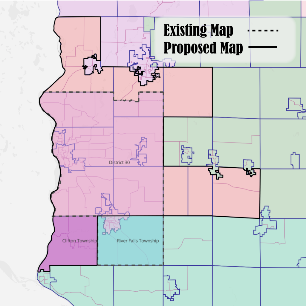
Leake pointed out one glaring change to the map now being proposed by the Legislature that impacts western Wisconsin voters.
District 30 used to include the Town of River Falls and the Pierce County half of the City of River Falls. Now that portion of the district has been carved off and added to District 93, which stretches from the St. Croix River to east of Eau Claire. To make up for the population loss, “arms” stretching to the north, south, and east have been added to District 30. The district is less compact and does not preserve the River Falls community of interest. It is also a less competitive district, with a distinct lean toward the majority party. Lack of competition will, said Leake, have a negative impact on UW-River Falls and the city as a whole.
“I call it Quadrapus, the monster that ate representation,” joked Leake.
Leake and a few other map-and-math enthusiasts recently founded the Wisconsin Map Assessment Project. It seeks to monitor and assess public redistricting maps from all sources, uses the assistance of experts to score those maps on a variety of criteria, and advocates for fair district maps in Wisconsin for the next decade.
The maps that Leake and his colleagues reviewed came from three sources: the web portal provided by the People’s Maps Commission (a body chosen by a group of retired judges to draw legislative maps for Wisconsin), the “Draw Your District Wisconsin” portal set up by the State Legislature, where regular citizens could submit maps, and the actual map proposed by the legislature.
There are many ways to evaluate whether a map is fair or good. However, the independent, objective sources used by the Wisconsin Map Assessment Project to score maps are in general agreement. Good maps have districts that are contiguous (that is, they have a continuous, unbroken border), compact, contain roughly the same number of people per district, seek to preserve established boundaries (counties, cities, and towns), and protect the rights of minority voters per the Voting Rights Act of 1965.
Additionally, good maps preserve communities of interest (areas or neighborhoods where residents share common interests and bonds that deserve consideration by elected representatives). Finally, good maps are competitive and proportional; that is, they lead to outcomes that reflect the results of the past five years of statewide elections.
Leake’s team found that the Assembly map that is being proposed is rated the worst of all maps submitted to the legislative portal in three of five categories: proportionality, competitiveness and compactness. It was also well below average on the splitting of counties.
You can call or write your assembly representative and state senator to tell them you oppose the proposed maps (the bills are SB621/AB624).
Learn more by checking out Pierce County GrassRoots Organizing/Western Wisconsin for Nonpartisan Voting Districts at gro-ww.org/.